Audio tour
Saka Manor legends, military history, Saka Manor landlords throughout the ages, waterfalls and geographically special location.
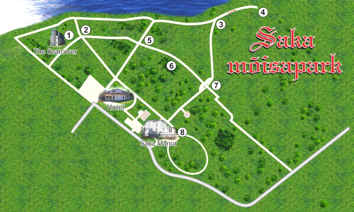
You will need: smartphone, internet and, if desired, headphones when visiting various places.
Tour
- Border guard tower Meretorn
- Memorial to Baltic Germans resettled from the Baltics in 1939-1941
- Flight through the Iron Curtain
- Saka waterfall (Kivisilla waterfall)
- Arrival of Kalev
- Bunker Hill
- Stone exhibition “The Passing of Time”
- Saka Manor Mansion
Tips
Bring along your friends, your good humour and enjoy the tour. At the last tour point, be sure to visit Saka Manor restaurant.
To use the audio tour, click on the numbers on the map. Next, an informational material will open for you to listen to.
The Saka Manor audio tour is especially designed for interesting listening on the side of a walk.

1. Border guard tower Meretorn
What we call Meretorn or Sea tower, is a former Soviet border guard searchlight building, also used as a watch tower. When the Saka manor complex was restored and started as a tourism manor, the towers new main function was to be a conference center which offered four halls of different sizes. The two halls on the higher floors were later remodeled and turned into exclusive accommodation.
2. Memorial to Baltic Germans resettled from the Baltics in 1939-1941
There is a memorial six meters tall on the limestone plateau between the Meretorn and the camping house. It’s a memorial to the Baltic Germans that were resettled from the Baltics between 1939 and 1941 – it represents storks flying west through an open window.
3. Flight through the Iron Curtain
Mathias Rust, an 18-year-old German recreational pilot, flew over this spot with the small plane Cessna Skyhawk 172 on the 28th of May as part of this notable journey to Moscow’s Red Square. This audacious flight cost Rust 432 days in Russian prison, but ensured him the admiration of the whole world.
4. Saka waterfall (Kivisilla waterfall)
With it’s drop of 22.8 metres, the Saka cascade is the second highest in Estonia. The highest – Valaste (30.5 metres), and the third highest – Karjaoru falls (12 metres) are located close by, only a few kilometres away.
The Saka cascade consists of three larger (6.0 m, 2.0 m, and 7.5 m) and several smaller (up to 1 m) steps. The cascade falls approximately 48 meters to get from the cliffs to the sea.
Music recommendation in this point.
5. Arrival of Kalev
The first story of the epos “Kalevipoeg” is “The arrival of Kalev, Salme and Linda, Wedding” which tells about how Kalev arrived on the high beach of Viru on the back of an eagle. The thought that why should Kalev not arrive here at the high bank, started growing its’ roots in the head of Saka’s manor owner decades ago.
6. Punkrimägi (Bunkerhill)
After the last of the family members that lived in Saka manor – Löwis of Menar – left to Germany on the 3rd of November 1939, Saka turned into military grounds. The strategic position on a high cliff above the Gulf of Finland provided a good stronghold for the military both to place artillery batteries and to guard the sea border. Militaries of three different countries have located in Saka manor and park over time.
7. Stone exhibition “The Passing of Time”
The stone exposition is located in the eastern part of the Saka manor park by the park road rising in relief and consists of decorative boulder-sized rock monoliths (diameter over 1 m). The age of the stones changes from older to younger ones as the road rises, just like the passage of time.
8. Saka Manor Mansion
Saka manor, previously known by the name of Suur-Saka (Groß-Sack), has been first mentioned in the 17th century. It is known that from the year 1620, Saka manor was in the possession of the Swedish crown. In 1626, the Swedish king Gustav II Adolf enfeoffed these lands to Jörgen (Jöran) Leslie from Aberdeen in Scotland. Twenty years later, Queen Kristiina confirmed that Saka manor still was in the possession of the mayor of Narva, Jöran Leslie, who lived mainly in Saka in his mayoral years of 1627-1649. At that time, the Saka manor was already important enough to be shown on the map of Virumaa drawn in 1696.
Join the newsletter
